Caldera Collapse
Most of the Kenya rift axial volcanoes have lost large areas of their summits due to formation of calderas (Fig. 1). Two of the largest calderas are south of the equator at Suswa and Menengai, with areas of approximately 20 and 80 km2, respectively (McCall, 1968; Williams, 1978; Randel and Johnson, 1991). North of the equator (Figs. 1,3), calderas are the size of Suswa or smaller, but due to less rainfall the details of the volcanically- and structurally-controlled topography are better preserved. Recent detailed structural mapping and geochronologic studies in the north have also established better constraints on the timing of caldera formation, and provided data for interpretation of Pleistocene stress fields (Dunkley et al., 1993).
Northern Volcanoes
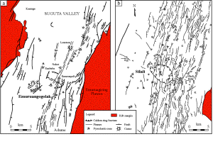
The fault patterns, eruptive centers, and ring fractures in the vicinity of Emuruangogolak and Silali illustrate many of the relationships common to the axial volcanoes (Figs. 3,4). Trachyte shield construction at Emuruangogolak began ~1 Ma, followed by a major period of faulting (Dunkley et al., 1993). Trachytic pyroclastic activity and eruption of basalts started at ~200 ka and continued to within the last few hundred years. Caldera collapse occurred between 38±6 ka and 27±5 ka (Dunkley et al., 1993). The caldera is 3.5 x 5.0 km, with a N56°W trending long axis (Fig. 4a). Cause of the caldera collapse has been attributed to withdrawal of the Enababa trachyte lavas (38±3 ka; Ar-Ar) from a high-level magma chamber beneath the summit (Dunkley et al., 1993).
The oldest shield trachytes exposed at Silali are ~225 ka (Dunkley et al., 1993). As at Emuruangogolak, initial construction of the trachyte shield was followed by faulting, pyroclastic deposition, and onset of basaltic volcanism. Caldera collapse occurred between 64±2 ka and 7±3 ka (Dunkley et al., 1993). Dunkley et al. (1993) interpreted the collapse to have formed due to a piston-like movement, triggered by magma withdrawal and lateral dyke injection, resulting in very regular, vertical walls that reach 340 m height (Fig. 2). The caldera measures 5.1 x 7.7 km, elongate in a N58°W direction. Most fissures, faults and volcanic cones are aligned N-S to N10°E, parallel to the rift margins (Fig. 4b). However, a well-developed NE trend is also locally present and is discussed below.
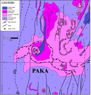
Timing for the formation of other calderas in the northern rift valley is broadly similar to that of Silali and Emuruangogolak. The slightly elongate N75°W oriented Kakorinya caldera on the Barrier at the south end of Lake Turkana (Fig. 3) formed between 92±2 ka and 58±4 ka, and the caldera at Paka at ~10 ka. (Dunkley et al., 1993). Although the Paka caldera is circular and only about 1.5 km in diameter, it lies along a N55°W trending, fault-bounded ridge together with several smaller craters (Fig. 5). The overall structure of the summit is therefore elongate in an orientation similar to that of the other northern calderas.
 |
Figure 5.Faults and volcanic structures of Paka volcano. After Dunkley et al., 1993. |
Southern Volcanoes
The timing of volcanicity and structuring at Suswa and Menengai is not as tightly constrained as that of the northern volcanoes due to the existence of fewer radiometric age dates. Based on Kenya Topographic Survey maps, the caldera at Menengai is about 7.8 x 12.8 km, elongate parallel to N47°E. McCall (1957) used correlation of ash deposits to interpret that this, the largest caldera in Kenya, formed piecemeal, at about 10 ka or less. More recently, McCall (1968) stated the age of formation to be "probably Upper (Late) Pleistocene." Due to the uncertainties in its age of formation, and our lack of more detailed structural data, we cannot presently include Menengai in our discussion of rift axis caldera and stress field evolution.
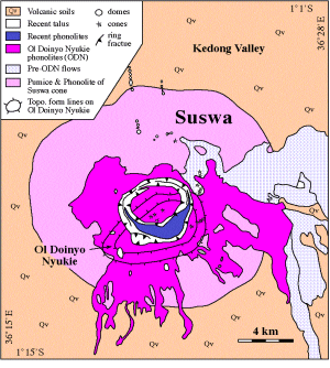
Suswa, the most southern of the large caldera-bearing volcanoes, experienced one of the most complicated documented histories of the axial volcanoes (Randel and Johnson, 1991). The main collapse caldera of this cone measures approximately 4.8 x 5.4 km, elongate along a N83°E (N97°W) axis (Fig. 6). Caldera collapse is now known to have pre-dated those of the northern volcanoes. Due to the marked dissimilarity in orientation to the calderas of the northern volcanoes, a brief discussion of Suswa will be important in our attempt to relate volcanic structure to stress field orientation.
The main shield of Suswa is composed of trachytes and phonolites that have been dated as 240±10 ka by Baker et al. (1988; Sample KSS-10, K-Ar). Caldera collapse was marked by the eruption of extensive pyroclastics and ring-fracture lavas (Randel and Johnson, 1991). These units are presently undated. Following the formation of the main caldera, additional volcanism occurred within the summit region of the volcano, focused at a new cone, Ol Doinyo Nyukie, located on the southwest rim of the caldera (Fig. 6). Two samples from this Ol Doinyo Nyukie eruptive phase both yielded ages of 100±10 ka (Baker et al., 1988; Samples KSS-18 and KSS-30; K-Ar). Following the formation of Ol Doinyo Nyukie, a second major collapse event occurred, producing an intra-caldera "ring graben", but was not associated with eruption of pyroclastics or lavas (McCall, 1963; Randel and Johnson, 1991). A very recent, minor lava flow was later extruded within the caldera, partially filling the southern part of the ring graben, and a minor fissure-eruption occurred on the south flank of the volcano.
The formation of the main (outer) Suswa caldera is therefore bracketed to have occurred between 240 and 100 ka. Despite this relative imprecision in timing of formation, the ENE-WSW oriented Suswa caldera is clearly older than any of the NW-SE elongate calderas in the north.

