

| |
|
|
|
|
|
|

|

|

|

|

|
|
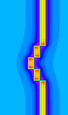
| In this model the apparent offsets are quite clear, although the results of section 2.2.5 show that the true offsets cannot actually be determined from this data. | ||||||
|
|

|

|

|

|

|
|
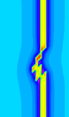
| In this case the fault positions are still quite clear in the magnetic data | ||||||
|
|

|

|

|

|

|
|
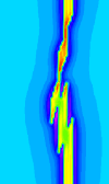
| In these images the fault positions and orientations start to become unclear, and the variations in dyke appearance along strike could be interpreted as thickness variations or rock property variations. | ||||||
|
|

|

|

|

|

|
|
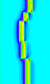
| This model re-emphasises the problem with reinterpreting true fault offsets from faults cutting a single marker horizon. (See section 2.2.5 for further examples.) | ||||||
|
|
|
)
)
)
)
)
)
)
)
)
)
)
)
)
)
)
)
)
)
)
)
)
)
)
)